Distance: 19-20km
Elevation Gain: 1500m+
Rated: 6.0/10
Gunung Nuang, this mountain is one of the highest in Selangor and also one of the most unforgiving terrain for most average experience hikers. With a height of approximately 1498m high (above sea level), this mountain is good for training purpose if one aim to hike other mountain such as G7 or G12. To get here by GPS, the following destination: "Hutan Lipur Gunung Nuang, Kampung Pungsun, Kajang, Selangor, Malaysia" can be used in google maps. Facilities provided here at the entrance are toilet, car park, cabin, and a store selling drinks. The forest entrance require permit which you have to apply through email:phdseltgh@yahoo.com. From there you have to go to their office at Cheras and pay.
 |
| A map to Gunung Nuang, Hulu Langat from Monash University Malaysia |
 |
| The hiking trail (Mapmyhike app) (Going up) |
 |
| The hiking trail (Mapmyhike apps) GPX file as in the link: https://www.dropbox.com/s/kanoveo5q6z0vbm/Gunung%20Nuang%20Hulu%20Langat.gpx?dl=0 |
The hike to the top of Gunung Nuang usually take one full day (around 9 hours), but one can opt to overnight camping to decrease the intensity of the hike. It usually take me 5 to 5.5 hours to climb to the peak and 3.5 to 4 hour to hike down if it is a full day hike. There are two camp site on Gunung Nuang if one want to overnight in Gunung Nuang and they are Camp Lolo (2 hours from main entrance and has river nearby) and Camp Pacat (3 hours from main entrance and water source is 5-10 minutes away). Of course, they are hiker that camp at the peak of the mountain but do note, the camping area can get chilly even at Camp Lolo (woke up at 3am before just to start a fire).
Along the hike, there are 4 common checkpoint along the hike. The first checkpoint is the ending of the "never-ending-winding-road" (this is also where you start the hike) which will take around 1.5 hour, the second and third checkpoints are Camp Lolo and Camp Pacat respectively, the last one is the "Puncak Pengasih" which is the false peak which is around 4.5 - 4.7 hours from main entrance. There won't be much to see along the path as the whole path are just trees and even at the peak, the view is limited to a certain angle only. The usual cut off time for the mountain is 1pm if you start at 7am and 12.30pm if you start at 6am.
Below are some of the photo of Nuang:
Below are some of the photo of Nuang:
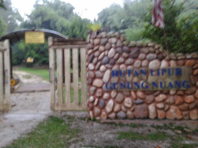 |
| Main Entrance of Nuang |
 |
| Stream in Nuang |
 |
| Rock stacking at the river |
 |
| Camp Lolo |
 |
| One of the many terrain of Nuang |
 |
| Wild dog at peak top |
 |
| Peak Top |
 |
| The limited view of Nuang scenery at the peak |
There is a much easier side of the mountain which start at Janda Baik. Do take note, depending on the weather, the view here can either be meh, lousy and excellent. Of all the 15 times I been to the peak of Nuang, only once ever it was an excellent view.
The fastest I have gone for this mountain is:
Entrance to Camp Lolo: 1hr
Camp Lolo to Pacat: 55min
Pacat to Peak: 50min
Total Up: +- 2hrs 45mins
Total down: ?
Edited 26 Feb 2020