Distance: 17km
Elevation Gain: 1098m
Rated: 6.0/10
Gunung Yong Belar, it is the fourth tallest mountain in Peninsular Malaysia and Kelantan tallest peak. In this case, I don't really have a starting point of the trail as some you will note that there stairs and pipe to follow into the jungle... In this case, I was just following Peaks Outdoor and when we started our hike, we didn't have any of those and started at the "Sayur Kebun" or vegetable farm.
We parked at Guan Di Temple, "4.565557, 101.410713" and from there take the rented 4WD toward the trail head which suppose to drop us at a supposing black metal gate and walk a few kilos to the trailhead, but apparently our driver manage to drive in deeper and save us a some kilos.
Our 4WD manage to reach this point "4.620956, 101.406523" (1 on map) and we started walking from here and past the farm. The trail head start roughly at this point "4.623977, 101.400385" (2 on map).
There is no public facilities here and make sure you arrange with your jeep driver on the timing to fetch you back as there is no phone signal here. Also, this hike does not required guide but permit is required from the Forestry Department.
 |
| To Guan Di Temple from Monash University |
 |
| Above Maybank is a homestay we stayed for the night before the night |
 |
| The start of our hike where our 4WD drop us (1) and trail head (2) |
 |
| Yong Belar Hike https://www.strava.com/activities/1671872215 |
The Yong Belar hike is not really the toughest mountain among the G7 mountain, in fact it might one of the easiest G7 out there but it should not be underestimated. It difficulty is comparable with Gunung Nuang Hulu Langat except you have to deal with plentiful of mud pool halfway through the top.
The hike start of with plenty of up and down but on the first km you will be blessed with a wonderful view if your day is all clear. There are quite plentiful of view as your transverse along the mountain until Camp Tudung Periuk, roughly 3km and 2 hours in.
After Camp Tudung Periuk, it all forest hike with more up and down. But not to far, you will start to hike along the mossy forest. It pretty and nice but the mudpool all over the place can be annoying at time.


 |
| The start of the hiking trail |
 |
| The view |
 |
| Tok Nenek (Right), Bubu (Mid) and Yong Yap (Left) view |
 |
| First Checkpoint / Campsite (~3km in) This is the only water point |
 |
| Camp Tudung Periuk (turn left down to continue on) |
After Camp Tudung Periuk, it all forest hike with more up and down. But not to far, you will start to hike along the mossy forest. It pretty and nice but the mudpool all over the place can be annoying at time.


There is basically no view from this point onward but roughly 6.5km in and 3-4 hours later from start, you will reach a second campsite known as Camp Kasut. There nothing much to do here but rest, but if you can go on, do so as you are only 1.5km or roughly 1-1.5 hours to the peak only.

After Camp Kasut, you will be greeted with more mossy forest.
After all that, 2 minutes from the peak, you will reach a small junction but if you pay no attention, you should not see it in the first place. But do take note if you going back as a wrong turn there will bring you to a whole different hiking trails.
After the junction, you will reach the peak and if lucky, the view should be awesome and you can see Gunung Korbu, Gayung, & Junction!


The hike up to Yong Belar is not really fun due to plenty of mudpool but if you lucky, the view up here is extremely rewarding!
Last edited

 |
| Come in from (1), go to (2) for the peak |
After Camp Kasut, you will be greeted with more mossy forest.
 |
| Climb through the tree root Like Viper Challenge but wilder and not skippable |
After the junction, you will reach the peak and if lucky, the view should be awesome and you can see Gunung Korbu, Gayung, & Junction!
 |
| The Mini Junction (1) is only 2 minutes from the peak (2) goes to Trans-Titiwangsa V1 or V2 (3) is a state border rock |


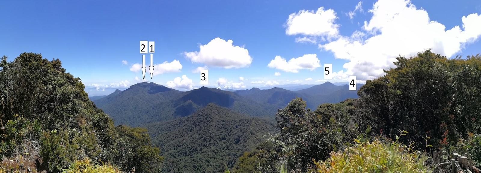 |
| (1) Gunung Korbu (2) Gunung Gayung (3) Gunung Junction (4) Gunung Bubu (5) Gunung Yong Yap It basically the whole of Trans-Titiwangsa V2 viewable on very good weather |
Sunset at Camp Cabin
Time log for this hike:
8:35am - Start
10:10am - Camp Tudung Periuk
11:45am - Camp Kasut
12:35am - Yong Belar Peak (rest 1:30hrs)
6:00pm - End of Hike
Other info:
4WD number to drive into the trailhead: +6017-318 5171
Other info:
4WD number to drive into the trailhead: +6017-318 5171
Last edited
21 January 2019