Gunung Yong Belar - 3 Boundary (via Camp Kebun)

Distance: 21km
Elevation Gain: 2098m
Rated: 7.0/10


Gunung Yong Belar - 3 Boundary also known as YB3B is a trans-hike from Camp Kebun to Blue Valley Dam (though the ending point for us is not at the stair...) The distance difference between just Yong Belar and YB3B may look the same, but the route is a completely different story. Do not underestimate this route as many I know did so and paid the price of having to hike in the dark...

The hike up to Yong Belar from Camp Kebun is the same as the following blog:

https://www.strava.com/activities/3101214614
GPX Link: https://www.dropbox.com/s/7kvs4x6ap24czve/Yong_Belar_Charlie_3_Boundary_6040.gpx?dl=0


The trail from here onward isn't the same as the trail from Camp Kebun. It actually more identical to the route toward Trans-Titiwangsa V1. It not as muddy as it is and it actually very beautiful. Though do take note as this route is rarely taken by hikers, it can be raw and trails might closed up. 

It best to bring someone who is familiar with the trail as even the trail nearing the end also known as the pipe road can be confusing. It does have markers but at night, they are not easy to spot. Even though we reach this part of the trail with lots of daylight, it still wasn't easy to track the marker. 

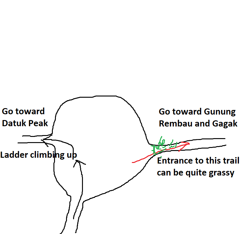
Trail Junction at Yong Belar Peak

The first stop from Yong Belar is Camp Gurkha which is 4.5km. But don't let the distance fool you, the trail is technical and the "dragonback" like trail will tire those who are not prepared. During our time, we were very lucky that the trail was already cleared by another group of hikers beforehand. Typically, it may take up to 5 hours just to reach here if you rest and stop a lot. 

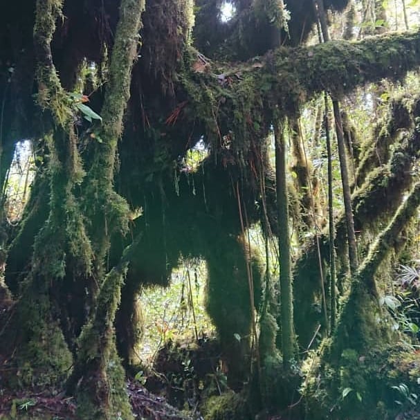
The whole trail is a mossy forest heaven till Camp Gurkha, do take your time to enjoy it.


After 4.5km of hiking you will reach Camp Gurkha, do refill your bottle here as there won't be any more water source until near the end of the trail. Do rest and eat here as the climb of up and down starting here.


Camp Gurkha Site

After that, it a 1.3km climb up to Gunung Challi. typically may take up to 1.5 hours to reach the peak.

Gunung Challi

There isn't anything much up on this peak though. We eat for a while and went straight for 3 Boundary Peak as there has 360 view. After 1.5km of hiking down and up through the beautiful mossy forest, we finally reach 3 Boundary Peak where the view is amazing... Well, sadly not for our case as it was cover by a piece of A4 paper.

3 Boundary Peak

The next and last checkpoint is Gunung 6040 which is 2km away. With more up and down and false peak, it only a matter of time we reach the last peak. Typically, it will take up to 3hours just to get here. 

Gunung 6040

Like Gunung Challi, there isn't much here to see either but at least the forest trail toward here is still beautiful. And at least from this point onward, it only downhill to the trailhead, 4km of downhill. Though the trail still does remain fairly technical so it still not easy going fast. It is almost impossible to run especially at the trail full of pipe. As mention before, the trail is fairly well marked but once you reach this part in the dark, please be on the lookout as there is quite a number of fork-road. I stop taking pictures from Gunung 6040 as my phone was dying...

The endpoint of the trailhead is a tar road where if you head left, you will go to the Blue Valley Dam and a right turn will bring you out near Masjid Loijing.

Trailhead of YB3B (4.5km, not 3km*)

Overall, it a very nice trail to hike on but you have to be prepared and fit to finish the route. We started at 3am from Camp Kebun and end the hike at 5pm, though we could have finished it 2 hours earlier but sometimes waiting for your group is also part of the mental training. 

Yong Belar peak -- Camp Gurkha (3-5 hours) -- Gunung Challi (0.75 - 1.5hours) -- Gunung 3B (1-2hours) -- Gunung 6040 (1-3 hours) -- Trailhead (2-4 hours)

Last edited:
17 May 2020


Gunung Tok Wan and Puncak 18 via Broga Hill

Distance: 12km
Elevation Gain: 1000m+
Rated: 5.0/10

Broga Hill

Gunung Tok Wan, 677m and Puncak 18, 815m. Both mountain is a continuous hike from Broga Hill trail. The view on top of Broga is as nice as you will see in the photo but the place very often gets overcrowded which will make the hike very hard to enjoy. 

Get to the Broga Carpark

To get here, use [2°56'19.7"N 101°54'05.0"E] or Broga Hill Park. You have to pay RM1 for the Carpark and then another RM1 for the Broga Entrance (which is inside the hike). There is no eatery here. There is a toilet here but I heard you need to pay if you want to use it. Carpark is plentiful but easily filled up if you come in late. There no permit nor guide required. 

Going to the peak of Broga is as simple as 123. The trail to the first, second, and third Broga peak is straight forward but do note there is another trail that can skip straight to the second peak of Broga.


https://www.strava.com/activities/2964136080/overview
GPX Link: https://www.dropbox.com/s/h2qnoybsd7yrthi/Broga_Tok_Wan_P18_Tok_Wan_Broga_Tok_Wan_P18_Broga_CP%20%281%29.gpx?dl=0

After the easy hike up to Broga, the trail heading toward Gunung Tok Wan is well marked and it a single track all the way. 

Before you make your way toward Puncak 18, do note there is no water source at all. From Broga third peak all the way to Puncak 18 and back will take an average of 5-7 hours and do not forget that returning to Broga barren land after Puncak 18 means it going to be in the middle of the hot afternoon! So water must really bring enough!

The third peak of Broga going toward Gunung Tok Wan

After 3km of climbing up which typically takes other around 2.5 hours, you will reach the not-so-amazing Gunung Tok Wan. Most hiker only comes here to punch passport and others will come here as training. But all in all, a lot will stop here and return back to Gunung Tok Wan. It up to you if you want to continue onward to Puncak 18 as that peak isn't amazing too...


Gunung Tok Wan, turn right toward Puncak 18

Turn right toward Puncak 18

If you do want to continue to Puncak 18, do note the trail up will be rawer as there isn't a lot of hiker going up to that peak. It another 1.3km up to Puncak 18 with quite a steep climb, typically will take around 1.5hours up and down. 

The peak of Puncak 18

There isn't much to see at both peaks after Broga. It does make for a good training spot though and with the barren land of Broga, it also makes a good place for heat training. Do note the forest can be very quiet after Broga third peak when nobody is going up to Gunung Tok Wan.

Trailhead -- Broga 3rd Peak (1.5hours) -- Gunung Tok Wan (3 hours) -- Puncak 18 (1 hour).

Last edited:
16 May 2020


Gunung Rembau and Gagak via Datuk

Distance: 11km
Elevation Gain: 1100m
Rated: 5.5/10

Gunung Rembau and Gagak is a continuation hike from Gunung Datuk. For info on Gunung Datuk: https://keeminginsj.blogspot.com/2014/09/gunung-datuk.html

After your 2km climb up to Gunung Datuk, be prepared to climb some more. Do note, on both peaks, there isn't any view to enjoy which is why they are very least visited. This route also shared the same route as Trans-Naning which will bring you all the way to Gunung Tampin. The trail is quite straight-forward but you might be better off with someone who familiar with the place.

https://www.strava.com/activities/2884487739
GPX Link: https://www.dropbox.com/s/x1bpnsyop2q7wbn/Gunung_Datuk_Rembau_Gagak.gpx?dl=0

Gunung Datuk Peak, Turn right toward Rembau & Gagak

After 1.5km of hiking up another session, you will reach a Gagak and Rembau junction. Turning left here will bring you to the peak of Rembau (500m away) while turning right will bring you to Gunung Gagak. Gunung Gagak is 1.5km away from this junction but it not as steep as the previous 1.5km. You will go through the series of up and down though.

Gunung Gagak

Gunung Gagak Peak

Gunung Rembau Peak

Gunung Rembau

Rembau - Gagak Junction
1. Turn left to go Rembau
2. Turn right to go Gagak 

There isn't much to see here, most hiker will come here to apply passport only... Other than that, the trail do offer a nice elevation gain, but with the trail being very quiet, it better to just hike Gunung Datuk two times then to come in here.

Trailhead -- Datuk (2 hours) -- Junction (1 hour) -- Gagak (1 hour)

Last edited:
16 May 2020


Gunung Berembun and Telapak Buruk (Crash Site only)

Distance: 17km for Gunung Berembun and Telapak Buruk, 12km for Gunung Berembun only
Elevation Gain: ~1,200m for Berembun and Telapak Buruk, ~1,000m for Berembun only
Rated: 5.5/10 for Berembun and T.B., 5.0/10 for Berembun only

Gunung Berembun is situated at Pantai, Seremban.With a height of around 1014m from sea level, there isn't actually much to see on top of the peak. The interesting part is usually at Telapak Buruk which is around 2.5km from the peak.


The trailhead is at "2.801997, 102.022832". There is no public facility around here which means there no toilet or eatery, but there is a river at the side to take bath. The permit can be bought on the spot. The guide is not required, the trail tends to be quite straight forward but preferably you bring someone who knows the trail. 

Park the car on the side but make sure you do not block the road

Direction to the trailhead

https://www.strava.com/activities/3120947141
GPX File: https://www.dropbox.com/s/2fa0t5f4nqi2dru/Crash_and_BerenBURN.gpx?dl=0

The entrance, there is someone at the gate for the permit

Gunung Berembun is only 12km up and down, it is quite an easy hike, though there isn't any view up there. The mountain is good for training for your elevation gain especially after Camp Gua Kambing. The trail as mentioned is quite straight forward except Lata Berembun. 

Lata Berembun (roughly 2.2km in)

Be careful not to go straight here 

After Lata Berembun, another 2.2km will bring you to Camp Gua Kambing. There isn't any "Gua" here though. Do note, if you planning on pushing to Telapak Buruk crash site, many will recommend refilling your water bottle here. Yes, there is water at the crash site, but with all the metal lying around that river, I rather not drink from there. (Do note: yes, I tend to drink from the river without filter, but it always is safe to carry a filter or chlorine pill.)

Camp Gua Kambing

Hold Left to go to the peak


After Gua Kambing, here will be your steepest session of the hike. Around 1.5km of climbing, you will finally reach the peak. If you want to head over to Telapak Buruk, that will be another 5km to and back, but it quite a flat hike.

Gunung Berembun Peak

Peak going toward Telapak Buruk

The route toward Telapak Buruk is straight forward, there is some fork on the way but they tend to connect back later on. But always ensure you know what you doing before simply taking any turn in the forest. After 2.5km, you will reach the crash site area which you need to turn to the left and climb down toward the crash site.


Telapak Buruk Crash Site

Point 1: Plane wing crash site (3min walk)
Point 2: Plane fuselage crash site (3 min walk)
B. Go toward TM Tower or Peak of Telapak Buruk
C. Down another crash site, but it a 20minutes steep down and I myself haven't been down there.
Crash Site Point 2

Crash Site Point 1 (Turn left toward point 2)

You can go toward TM Tower if you are up for the challenge, the following trail is as the link:

The crash site is diminishing since the last time I went 3 years ago, and it will definitely continue to disappear.  Please don't take anything out of that place and let other enjoy the area.

Typical time:
Trail head -- Lata Berembun (1 hour) -- Gua Kambing (1 hour) -- Peak (1 hour) -- Crash Site (1hr15min)

Last edited:
16 May 2020