The Magnificent Merapoh Trail, 70km (August, 2017)

The Magnificent Merapoh Trail. A trail running event around Merapoh, Pahang park with three distance of 30km, 70km and 100km. As I did not finish any ultra race before hand, I knew 70km is going to be a big challenge for me especially with a cut off time of 13 hours, but I was determine to at least finish an ultra marathon before this year end. So I registered and waited for the time to come but then I had a minor problem.

While training for TMMT. I had a minor injury with my knee which resulted to little or no training for this marathon three month prior to it. The only training was probably one of the 22km night marathon 3 weeks before TMMT but other than that, I did not collect any mileage. Nevertheless, I went ahead. 

5th August 2017, my knee gotten a lot better and all my ultra runner friend was with me this time, MF, TF, CK and Quan (Yes, sadly they are the only trail running friend I have now but it was much better than the last time where I had none). We went the day earlier before our marathon using their transport service to Merapoh. Once there, we bunker down, shower like those Japanese public toilet, eat very basic food prepared by the local but it was nice, and went for early bed since our marathon were at 4am.

Unfortunately, as I went for bed at 8pm, I couldn't really get some rest since it was a bit cold (they had no blanket and I was nervous like hell) and I was actually having a bad toothache. No proper training with not a very good start condition, I thought that it... this maybe another DNF race or worst, DNS race....

At 2am, it was time, woke up feeling quite bad.. Almost wanted to DNS the race.... But after saying a few grace and prayer, washing myself up and just clearing my mind. Something told me why give up so early when it haven't even started, DNF mah DNF lar, but don't DNS a race.... At least before you DNF, you get to see the beauty of the trail got to offer. So I set myself a target, before I DNF, I must at least reach the cave part of the trail.

My starting item were 1 litre of water mixed with hydration pill, 5 energy gel, extra battery for head lamp, headlamp, sandal, a tube of hydration pill contain 14pills, some raisin and a banana. My drop bag contain 5 more energy gel, change of cloth, extra headlamp with battery, more raisin and spare sandal. Also had an action camera with me. Even with not at my best initial moment, I told myself all I have to do is just keep focusing on the next water station, small bit by small bit and you will get there.

4am, drop off my drop bag and everyone was at a starting line. My second attempt on ultra marathon and my first ultra trail marathon was about to unfold. Everyone was eager to start, my friend and me were all laughing. Then the bell rang and everyone start running into the dark forest.

The initial 5km were mostly just wide open dirt road running which everything went smoothly, after that, it was along the oil palm plantation road and dirt road. Thankfully all was dry so one can just run without focusing too much on avoiding on slipping (it can be very tiring). Elevation was flat and it was easy to run, but to save my energy, I was running slow at 6km/h or 10min/km in the dark forest, sometime alone with just the headlamp lit-ing up the path. It can be scary but I did night jungle marathon beforehand so I wasn't too terrified when I was alone.

After 15km, it was that part of the race... Around 2km+ of not river crossing but running on river with depth varying from foot ankle to as high as stomach level with the starting point that one must climb up mini waterfall in the dark. It was a very slow and the water was cold and after 1km of it, agonizing. As I was reaching the end of the river run, the day was almost brighten up. Turn off my headlamp but I was a bit tired to bother about placing it in my bag. I didn't bother resting and the run  continue... 

As I was running, I notice I was a bit behind schedule for the next checkpoint cut-off time no thanks to the river run. I buck-up, took a sip of energy gel, eat up my banana, drank my water and ran for the cut-off time. Running along the rubber plantation. palm oil plantation and sometime just wild jungle trail, it what one would expect running in the trail of Malaysia. 

Reaching the 24km mark, it where our drop bag are located. I took some rest time off here, change my cloth since they were soaked. refill all my energy gel and raisin and decided not to change into my other sandal. Took a 10 minutes rest, and off I go aiming for the next checkpoint that has a cut-off time which was another 10+km away with 2hours more.

After 1.5 hours of running, I finally reach the first checkpoint with a cut-off half an hour early and sweet mother of heaven, they have cup noodles and plenty of other food. Knowing my time is not really on my side, I prepared one of my fastest instant noodle in my life and ate some of the bread and rice prepared. I was out and running again after 10+ minutes eating and resting.

From here onward, it was going to be a hot run. It was 11am with the sun shining down on some of the barren land we were running on. It certainly was not easy and with each water station distance between 10km average in between, I knew I have to carefully plan my water consumption and conserve as much energy as ever before, only running downhill and a slow hike uphill. Before this we were running in the cool breeze morning, now we were running under the blazing hot sun. 

Not long after that, we finally reach the cave of Merapoh. I was ahead of time at this point here so I took some time and just enjoy the view of the caves. Though the journey through the cave was short, it was one of the best moment in my running life. There were two cave run which is separated by  around 7-8km run under the sun and along the estate. After reaching the end of the second care, Gua Persik and it checkpoint, I never had so much joy before. With 4hr15min and another 21km more, although my leg was not at it best, I knew I can still hold on and finishes the race. I push on...

There was a last checkpoint between where I was and the finishing line, which was roughly 11km and I needed to get there by 3pm (it was 1.45pm at that moment). To normal runner, that plenty of time to cover, unfortunately under my condition, my best I could pull of was only 11.5min/km or 5.4km/h but I was confident I can do this. Keep telling myself, it only 11km more. 

Luckily on this section, the view maybe boring (and also saddening) as we were running along the deforestation of our forest and along road construction but I found someone to talk with along, for the next 6-7km, we were at the same pace and somehow the kilometer were just flying past. After that, we ran at our own pace which is also good and fun as sometime as he cut me off, this actually motivate me to push myself to end the race. 

55km and the last checkpoint. Boy I was dam happy to see this checkpoint and reaching it before 15min cut-off time. I knew I can do this. My first ultra marathon finisher. But of course, there was the last obstacle. With the last 10km and 2hour more to spare, it was still not going to be easy as this section has the longest uphill trail which will reach the maximum elevation of this race course. That trail section alone was 5km and after that it was my most hated type of marathon... Road marathon... Come to think of it, majority of the trail before this was on dirt and jungle road since I was complaining a lot in my head on this part of the marathon.

The last 5km road marathon was more tiring than the previous 5km uphill but it wasn't physically tired, it was more toward mental. I just feel like sitting down on the grass and lied down for a while... But on all my hiking experience, I knew that "for a while" is going to cause my finisher. One step after another, there it was, the finishing line... It was an emotional finish for me even though I was one of the last few to finish. Tear of joy roll down as the emcee called out "Lim Kee Ming has finish the 70km race in 12h43min!"  as I was desperately looking for coconut water...

The Starting

Climbing up the mini waterfall

River Run

River Run


Rubber Plantation


Moar Rubber Plantation

HOT!!


Farm Area

Almost at the cave point

The first cave

The second cave

The second cave

The second cave
The last 21km and it still HOT!!

FINALLY!! WITH 20 MINUTES TO SPARE
http://www.mapmyhike.com/workout/2377492283

TMMT 70KM Done!

TMMT 2017, 70KM


The Magnificent Merapoh Trail was indeed magnificent and eye opening. The cave was beautiful and never realize so many villager still rely on our forest reserve to put food on the table for their family. With the deforestation going on there, I do hope the government at least control every activity is going on in there. 

This was my first ultra trail marathon but it definitely not my last. It was fun but also very tiring. Thanks God for being there for me, I was at my worst at the start but this race ended up one of my best marathon in my life. Suffered little to no cramp with minimal chaffing, never hitted the wall and did not vomit unlike most of my past marathon which had at least one of those problem. Nevertheless, it does not end here...


Edited: 1st October 2017


(Some will ask why go through the torture? All I can say it for the view and it kinda like hiking in express mode and it has become an addiction. There is one thing I usually won't tell the non-runner and only to the one who think running was impossible but still want to try it out, "I was once a non-runner too, I couldn't clock a single kilometer properly in the past until I was 21 years old. Running 10km was impossible for me during that time. Then my friend challenge me to a 10km marathon. Train for it but the training was very tough and right to start of that marathon I kept on telling myself that this 10km marathon will be my first and last marathon... Little did I know, I would be here... Of course there were plenty of hardship in between, had 2 DNF marathon, never had a proper running buddy, all the "negative comment" saying your leg will not take it or you just not meant to do it... Thankfully, I found a few friend and got back my motivation and decided to go further than ever..." One can say, I mainly doing this for the nice view the trail has to offer and where hiking will take too long to reach but also at the same time, maybe inspired anyone out there who maybe going through the same trouble as me in the past... And also partly, this has turn into an addiction)

Gunung Nuang via Janda Baik

Distance: 14km
Elevation Gain: 1000m
Rated: 5.5/10

Gunung Nuang, this mountain is one of the highest in Selangor and also one of the most unforgiving terrain for most average experience hikers. With a height of approximately 1498m high (above sea level), this mountain is good for training purpose if one aim to hike other mountain such as G7 or G12. To get here by GPS, the following destination: "Janda Baik Starting Pt Gunung Nuang" on Google or "3.303979,101.887121" can be used in google maps. Facilities provided here at the entrance are toilet and car park. The forest entrance fee is free but car park is RM7 per car. Guide is not mandatory. (Note: I just found out this side require permit, but.... )

The route from Monash University Malaysia to the entrance of the forest road

The close up of the route

After an hour+ drive, you will reach the entrance of the hiking trail. Once here, there will be a gate on your left and river with stone wall on your right. Park your car at the car park for RM7 per car, it has toilet facility for your use for free.

The hiking entrance, on your left is the car park and on your right is a river with the trail starting point.

The start of the hike (and yes, that a river crossing)

Hike to the peak (Apps: MapMyHike)
GPX File Links:

The hike to the top of this mountain is easier compare to the Pangsoon / Hulu Langat side of Gunung Nuang but it still should not be underestimated especially for those who are new to the hike. It will take an average of 4 hours hike with occasion rest to the peak. As you hike through the farm, you will reach upon a crossroad, keep going straight to continue onto the mountain peak.

After walking through the farm land, go straight at this crossroad

Add the waterfall junction


It take roughly an hour and a half, depending on your speed to reach the first camp site which is the waterfall. As you reach a river, crossing the river will bring you to a junction which left will take you up to the peak and right will take you to the waterfall. After the waterfall, it all uphill from here for the next few hours.

Roughly after an hour from the waterfall, you will reach a second campsite, though, there is no nearby water source as far as I remember. After that, roughly another 30min to 45 mins, you will reach the junction where one side go to Bukit Repin and another to the peak of Nuang. Remain on the left at this junction. (note: if you want to hike to Bukit Repin, there a much shorter route than this, this is just a second path to the peak of Bukit Repin)

The second campsite

Left to Gunung Nuang, right to Bukit Repin

After your 4 hours of hike, you will reach the peak of Gunung Nuang. Do take note, depending on the weather, the view here can either be meh, lousy and excellent. Of all the 15 times I been to the peak of Nuang, only once ever it was an excellent view.


Sometime you gotta squeeze through this fallen bamboo

Waterfall of Nuang, Janda Baik 

Once you see this rock, the peak is very very close

This is one of the excellent view of Nuang which after 15 times to the peak, it my first time see-ing it

Genting Highland

This route is suitable for anyone who want to see Gunung Nuang but rather not take the tougher side of the mountain, or get a feel of how Nuang hike is before taking on the Pangsoon/Hulu Langat challenging side.

Edited: 2/9/2017

Gunung Telapak Buruk via Jelebu (WW2 plane crash site)

Rated: 3.0/10

Gunung Telapak Buruk, a height of 1193m above sea level is well-known for it WW2 plane crash site. Gunung Telapak Buruk is situated in Seremban which is roughly an hour plus drive from Kuala Lumpur and although the mountain is 1193m high, your starting point elevation is already quite high and to reach the crash site, hiker will only need to climb down and up through a valley to get here. (Note: this site can also be reach from Pantai entrance where hiker will climb to Gunung Berembun peak and another 2 hours to hike down to the crash site)

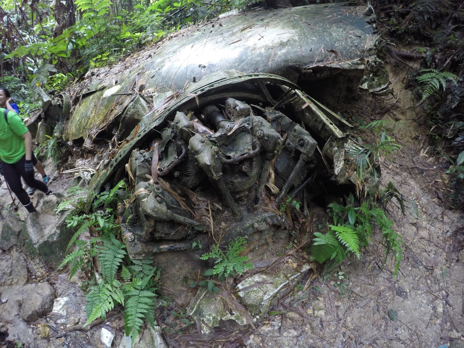
Here, you will be able to see the crash site of a B-24 Liberator though half of the plane is missing from the crash site. It is still a very different experience from most other hiking. To get here, use the following coordinate: "2.840246, 102.068981". There no public facility here. Permit and guide is not required at this point of time of writing.
The route from Monash University Malaysia to the entrance of the forest road
You will reach this point after an hour drive. Turn right into the forest road.

It may up to 45 minutes depending on your car type and who in front of you to the hike entrance

The road condition while driving up the forest road 


After the forest road drive, you will reach a T-junction. TM building is on the left, the hiking entrance is on the right

A TM building
The hiking entrance

The road condition up to the hike entrance is bad but does not require a 4 wheels drive up. During this time of writing, a normal Myvi manage to reach the top, and a Perodua Bezza with 4 people in the car also did make it to the top. Just make sure your car brake is in good condition and your car isn't too low to the ground. After the 11km drive, you will reach a T-junction where on your left is a TM building and on the right is the hiking entrance. Cars were park on the side of the road before the T-junction.

The hiking profile:

A hike to the crash site (Apps: Mapmyhike)

The hiking start with a steep drop down to the valley and straight to the crash site. It around 2 hours+ of hiking and the trail are marked with a distance marker supposedly every 50m. You will reach Gunung Telapak Buruk after the marker read 2500m. Though this is not the end yet but here if you look to the left, you can start seeing crash debris. The main crash site is on the right where is another 200m downhill to the wing debris and another 100m through the small river after to the tail of the plane.

The last marker before Gunung Telapak Buruk though the trail is not really 2.5km far


Gunung Telapak Buruk (Looking left too see a plane debris,  going straight bring you another 2 hours up to Gunung Berembun, and going down right will bring you to the crash site)


Some of the crash debris (There is a lot more but definitely not showing everything here!!)

The hike is fairly easy for an average hiker but hiker need to take note that they will have to climb back up while going back to their car. The crash site is already 70+ years old so do not sit nor stand on the debris. Also note that this area is the burial area for all the crew who were on board of the plane so respect the area and DO NOT take any souvenirs home nor leave any rubbish in the area!! Overall it a very different hiking experience as you don't usually see these in nature where it is still well preserve by nature itself! 

Side note: If you do not want to go through the forest road, you can still reach Gunung Telapak Buruk from Pantai side by you would have to climb to Gunung Berembun peak and another 2 hours hike toward Gunung Telapak Buruk (I have not taken this route hence I do not know how long nor how far this route is)
Last Edited:
9 February 2017

Gunung Kerinci via Kersik Tuo

Gunung Kerinci, a volcanic mountain with a height of 3805m, it the highest active volcano mountain in Indonesia and South East Asia. Though the difference in height between Rinjani and Kerinci is only 80m, hiking Mount Kerinci is definitely much easier than hiking in Rinjani. A guide is definitely a must for this hike. Our guide for the trip was by a simple man alone with his group of porter, Mr Endatno Een (+62 852 6626 6992). Though it may not be as grand as Rinjani, he really did make this trip a memorable one. 

It was initially meant to be a 3D2N hike but we manage to do it in 2D1N and it is definitely recommended to do so. Did I make Gunung Kerinci sound easy? Well, it is relatively easier compare to Gunung Rinjani as all of us make it to the top unlike Rinjani where only half of us make it to the top, but it is still tougher than Mount Kinabalu and best it not to underestimate it.

On day one, we started our hike 10 minutes away from the entrance of the mountain, Pintu Rimba which is already 1809m high at 9am. It a short walk along the farm with a beautiful view of Gunung Kerinci to Pintu Rimba where the forest hike start. the trail from Pintu Rimba to the first checkpoint, Bangku Panjang and second checkpoint, Batu Lumut is an easy hike, both taking only roughly half an hour to reach. There is nothing much to see here though, a quick rest and we were on our way.

From Batu Lumut to the third checkpoint, Shelter 1 it took us 1 and the half hour to climb as the trail start to steepen, but it still ain't that bad. We had our lunch here while enjoying the view of the mountain it provided. After an hour of resting and eating, we continue on our hike to the last checkpoint, Shelter 2 which is our campsite.

It took us around 2 hours and 15 minutes for us to hike up to Shelter 2, which is roughly 3000m above sea level. The trail up to Shelter 2 started to get tough and it almost similar to hiking from Camp Pacat to False Peak in Gunung Nuang. The campsite was good and the porter there really kept as company till the night, serving us "pisang goreng", peanut, instant cup noodle, fried chicken and rice for both tea time and dinner. At 8.30pm, we sleep in to prepare for the peak.

6 hours later, in the freezing cold night, we woke up at 2.30am. Luckily our breakfast came with hot tea and coffee with bread. After that, we pack our bag to bring only the necessary to the peak and left the others stuff in the tent. The hike to the peak start at 3.20am and we manage to reach the peak at 7am. The hike here isn't as bad as hiking in Rinjani, the rock here may be loose, but you won't lose one step for every two steps all the way up. During the hike up from Pintu Rimba, there isn't much view until 3,400m high where everything open up.

At the peak of the highest volcano in South East Asia, it is definitely breathtaking. Even though the view here may not be as grand as Rinjani, but it is special in it own way as here we get to see down into the crater of an active volcano. We also get a full 360 degree amazing view at the top and we were lucky to get a clear day when we were at the top. After that, we went down to our campsite at about 11am, had our lunch and packed up for the hike down to Pintu Rimba.

Basically, you only need to climb 2000m of it and the total journey is only 6.6km one way. so this hike is OK for adequate fit hiker. As mention before, the whole group manage to reach the peak unlike during the hike in Rinjani. Though the view for this mountain isn't much compare to Gunung Rinjani, but it is magnificent in it own ways. This mountain isn't popular too as it is not easy to accessed as it required 8 hours drive from Padang, Indonesia to reach Kersik Tuo. But it is recommended? Definitely yes for me!

Thing we brought up:                                
A few cloths                                                
Sunscreen                                                    
Sunglasses                                                  
Walking sticky
Camera
Extra food snack
Toiletries, paper, plastic
Torch Light / Headlamp
Long Jones and Jacket and Glove

Thing we don't have to bring up (porter help):
2 days of foods and water (for water, ask your guide how much will the porter bring for you)
Tent and sleeping bag


Being transport to the base of Mount Kerinci

Mount Kerinci

The hike start


One of the view during the hike

The Hike

The Hike 


The Camp Site

The HIke


The Hike


The Hike

The Hike

Nearing the peak

The Peak

The Peak

The inside of an active volcano crater

All of us make it!

The peak