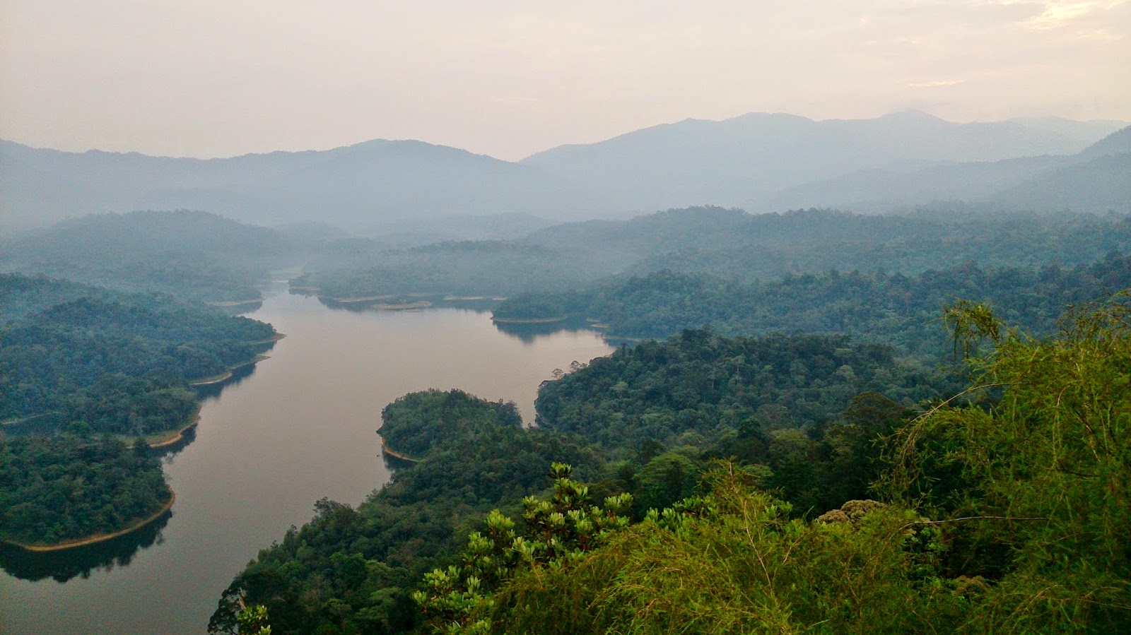
Tabur Hill (East Entrance)

Distance: 4km
Elevationg Gain: 200m
Rated: 2.5/10

NOTE: Entrance from the usual route has been fence up and blocked, the only entrance maybe through the village which you would usually exit. (There a trail beside the fence, walk along the fence then turn left at a T-junction)

As continuation from the previous entry, Tabur Hill (West Entrance), the story here will be similar.
Tabur Hill offer nice hiking and rock climbing experience for anyone who scale this hill. Tabur Hill, even with all the accident reports, I would still consider this side of the hill (west side) to be very safe as long as the hiker know his or her limit and know what he or she is doing. Do note, I would not recommend this hill to be the first hiking trip for any new hiker but go ahead if only you feel confident and would also not encourage hiking on the mountain while raining or right after the rain as the rock will be slippery.
To get to the path of the hike, one can use the following destination, "Jalan P 4, Taman Melawati, 53100 Kuala Lumpur, Wilayah Persekutuan Kuala Lumpur, Malaysia" or [3°13'55.774"N 101°45'0.468"E] as a guidance in this case. The actual spot to park your car and start hiking is shown in the map below. Just like the west entrance, there is no public facilities provided here.

A map to Tabur Hill (East Side) from Monash University Malaysia

A zoom in map to Tabur Hill (East Side)
Unlike the west entrance, the entrance point of the hike is not as grand as you seen in the west side. Although this side of the mountain also "required permit", but going early around 7, nobody will disturb you. On the east side of the mountain, the path up is tougher than the west side but the view up there is much nicer compare to the west side, to my opinion. I do consider the east side of the mountain to be safer than the west side of the mountain but do note, you still can fall and earn yourself a ticket to nearest hospital if not careful.

Trail route taken (Mapmyhike apps.) or
https://www.strava.com/activities/1779362675


The mountain hike up should take around 1.5 - 2 hours up and 1 hour plus down, depending on how much you want to stop and enjoy the view. Most of the path up are rock climbing style but it not very tough as rope are already provided to ease anyone. This hill can be loop around, which mean you can take an easier path after you done hiking up. You will meet with two fork roads in this case. Taking both right turn on the first and second fork road will lead to the exit around 350m away from where you started. Though,before heading to the right turn on the first fork road to head home, take the left turn for a final climb up to enjoy one of the best view that Tabur Hill can offer.

Park your car here and start the hike following the pipe
Just keep following the pipe

You will reach to the start of the path here
The dam

And that West Tabur Hill, the famous route up to Tabur


Taking the left turn will bring you up higher of Tabur Hill while right turn to head home
The last hike up to the highest peak can be a bit tough


The view of West Tabur Hill from the highest peak of East Tabur Hill

This part of the hill kinda remind me of Gunung Tahan

The view of Far East / Extreme Tabur Hill from the highest peak of East Tabur Hill
A huge fall if someone were to slip down

We made it!

The view of Far East / Extreme Tabur Hill from the highest peak of East Tabur Hill
The second fork road, take right to head home

This is the exit of Tabur Hill East, you are actually exiting through an orchard farm
(You will be able to see a lot of fruit trees around, but don't pluck them, it has it owner)
Exit at Jalan P3 where you have to walk back to Jalan P4 to your car which is around 350m apart
Overall, this hill does give that satisfying feeling of accomplishment if everything goes right. If you looking for bigger challenge, this Tabur Hill does offer one last tougher hiking trail which is Tabur Hill Far East and Tabur Hill Extreme. I am soon to complete that part of the hill.

(I have done Tabur Hill Extreme but Far East I may not plan to go)

NOTE: Entrance from the usual route has been fence up and blocked, the only entrance maybe through the village which you would usually exit.


Sadly the main entrance is being fenced up, though some are still able to make it to the top. I guessing they took the route starting from the village which you would usually come down from.


Last edited: 6 July 2017

Tabur Hill (West Entrance)


Tabur Hill offer nice hiking and rock climbing experience for anyone who scale this hill. Tabur Hill, even with all the accident reports, I would still consider this side of the hill (west side) to be very safe as long as the hiker know his or her limit and know what he or she is doing. Do note, I would not recommend this hill to be the first hiking trip for any new hiker but go ahead if only you feel confident and would also not encourage hiking on the mountain while raining or right after the rain as the rock will be slippery. To get here, one can use the following destination: "Jalan Kolam Air, Taman Melawati, 53100 Kuala Lumpur, Wilayah Persekutuan Kuala Lumpur". It is all the way to the end where you should be able to see the "puncak niaga facility" gate. There are no public facilities provided here.

The map to Bukit Tabur (West) from Monash University Malaysia


A zoom in map to Bukit Tabur (West)
Do note, ever since all the accident occurring up on the hill, the hill is only legally open on Thursday, Saturday and Sunday from 8am - 5pm [but 24/7 if no one knows ;) ], permit is needed to get before one can start hiking and there will be officer in charge. Personally, I really don't think all these permit nonsense will help with anything. There are many hiker who will avoid the officer by going early in the morning and start their hike before the officer start work. For me, I went during "Puasa Month" at 12 noon, hence, I manage to walk in without any interference. To obtain the permit, Pejabat Hutan Daerah Selangor Tengah is the place to go as shown below. The office will only provide the pass with a RM5 per pax fee on weekdays office hours only.
(http://www.streetdirectory.com.my/malaysia/kl/travel/travel_id_473972/travel_site_580198/travel_no_/)

The map to Pejabat Hutan Daerah Selangor Tengah from Monashu University Malaysia to obtain the permit

The zoom in map to Pejabat Hutan Daerah Selangor Tengah to obtain the permit
(I have not been there so not sure where to park)
With the tallest peak of around 450m+, the height is not that matter here. The fact that since Tabur is a range of hill, it is does provide some challenge especially to the newer hiker. It roughly took me 2 hours to complete all the peak and to the edge of Tabur before looping back down, which take another 45 mins to 1 hours to hike back down to the car. The first half an hour or so is an easy climb up, after that, the terrain will start to turn rocky and gradient of the slope will increase to the point where it is required to rock climb upward. Avoid making any mistake as a fall down of the cliff will almost certainly earn you a ticket to the nearest hospital.

Nevertheless, the view from the top can be breathtaking especially when one is catching the sun rise. It is possible to catch the sun set to, but hiking down in the dark at Tabur Hill is not the best idea. The Tabur hill trail can be done in a loop or if want, you can always climb back down the same way to come up for extra bit more of thrill. If you plan to take the loop down, do take note of the following fork road. Altogether, as I recall, there are three obvious fork road. Take left for all three fork road and you should be able to come out of Tabur Hill near the main entrance (Do note, I took the wrong turn at the third fork road, it did lead me out but at the wrong exit. Anymore fork road after the third one I am not very sure)

The entrance to Tabur Hill (West side)
The ranger will be waiting at the "pondok"
The peak ahead is Tabur Hill (East side)


The view of Tabur Hill (West)


"Wind Tunnel"
The first fork road after the "rock climbing" session
Take the left turn to loop around the mountain and back to main entrance, right turn for more view as below (dead end)

At the most west end of Tabur Hill

Hiking down Tabur Hill

Second fork road, unsure where right turn go, but take the left turn to head home

Third fork road, take the left turn to head back to the entrance
(In this case, I ter-took right turn and end up somewhere far from where I expect to be, as shown below)
If you mistook the turn at the third fork, you will end up at Jalan 1/4B, which in this case, happen to me

If you take all the correct path, you should be able to see this wheel once you finished the trail and is around 50m away from the main entrance
Overall, this hill does give that satisfying feeling of accomplishment if everything goes right. If you looking for bigger challenge, the Tabur Hill does offer two more tougher hiking trail which are Tabur Hill East and Tabur Hill Far East and Tabur Hill Extreme. I am soon to complete those part of the hill too.

(I have done Tabur Hill Extreme but Far East I may not plan to go)
Last Edited: 31 July 2014


Chilling Waterfall

Rated: 1.0/10  (Unless you plan to go up all the way to the third fall which is deep inside, 2.0/10)

Chilling waterfall, a heaven place of waterfall in Selangor. Located between the path of Kuala Kubu Bharu and Fraser Hill, Chilling waterfall offered one of the best waterfall scenery in Selangor, Malaysia. Unlike hiking any mountain, the elevation from main entrance to the 3rd fall of Chilling Waterfall is only 500m and can be done by anyone as the path up is more of walking instead of hiking. To get here by GPS, the following destination can be used: "Sungai Chiling Waterfalls, 44000 Kuala Kubu Baru, Selangor" or [3°35'56.67"N 101°44'14.506"E]. Facilities provided at the main entrance here are toilet and camping area. Car park is outside the gate of the park. The entrance fee in is RM1 and opening time is only on Friday, Saturday and Sunday (8am - 6pm). They do not open on weekdays (except Friday) even though it is a public holiday. There are time where the park will closed if the raining season is at the worst.

Map to Chilling Waterfall from Monash University Malaysia
The hike toward the first waterfall will take around 40-50 minutes. It is an easy hike toward the first fall and one required to cross the river six times before reaching the first fall. The river depth can be up to your waist, hence, getting wet is a guarantee, dry or wet season. The first fall is the main attraction of Chilling Waterfall and will usually be crowded with a lot of hiker. For a more comfy swim, hiker will usually hike up toward the 2nd and 3rd fall.

The path toward the second and third fall is "blocked" with a black and yellow ribbon and the path start before the sixth river crossing. This is just to prevent hiker from accidentally hiking up to the second and third waterfall. While hiking this path up, you will reach a fork road where left will take you to the second waterfall and right is the third waterfall. The hike to the second fall will take around 15-20 minutes and here, the pool of the waterfall has less people than the first fall.

The hike to the third fall which is the highest fall will usually take around 1.5 hours or less from the main entrance. When closing toward the 3rd fall, you will reach a fork road. Taking the one to the left will lead you to the bottom of the 3rd fall (but do warn, the gradient is fairly steep) and taking the one to the right will lead you to the top of the 3rd fall.

A little tip at the top of the 3rd fall, to be able to sit at the edge of the waterfall, you need to cross the river. One way to get to the other side without taking too much risk crossing at the edge of the fall is to cross the river around 15m - 20m away from the edge of the fall which should lead you back into a jungle path. Here, the path will guide you back out to the edge of the fall safely. While at the bottom of the 3rd fall, lies a beautiful pond where it is nice to swim since many wouldn't come this far, but as said before, the slope toward here is steep and there are cases where people slip and break their leg.

The entrance into Chilling Waterfall

The first river crossing and the start of hike up to the first fall
The first fall of Chilling Waterfall
Fishes and fishes at the first fall, they will nimble on your feet
First Fall
Midway of first fall
Above the first fall (hiking toward the second fall)

Second Fall of Chilling Waterfall

Second Fall of Chilling Waterfall

Above the Third Fall

At the edge of the waterfall

Overall, Chilling Waterfall is a nice place for relaxation and swimming with it beautiful waterfall. But do note, water is a powerful force and waterfall can create powerful underwater current. Do not swim too deep as the current can swept you away with ease. And never ever throw rubbish all over the place, this is after all, the water source for most Malaysian nearby.


Edited 26 July 2014